“The Hurricane Hunter Satellite constellation offers the potential to spot wildfires especially in remote regions”
Wildfires are among the most common form of natural disaster in some regions, including California, Canada, Siberia, and Australia. And as a result of climate change, wildfires are becoming more common, widespread, and destructive especially as urban areas encroach on formerly undeveloped wild lands. There are a variety of methods available to detect the presence and monitor the progress of wildfires, especially near populated areas where residents can spot them and report to local authorities. But in order to get a more synoptic view of a wildfire or detect them in remote areas far from population centers, remote sensing by aircraft or satellites is required.
While wildfire spotting using conventional 2D imaging techniques has been widely used for quite some time, the availability of 3D views created using stereography potentially offers new insights about the progress of wildfires and the plumes of smoke they generate. On August 13, 2018, what is today the TWA science team performed a stereo imaging experiment of wildfires in northern California from the International Space Station (ISS) as an extension of the CyMISS (tropical Cyclone intensity Measurements from the ISS) program.
Funded by a series of grants between 2014 and 2019 from CASIS (Center for the Advancement of Science in Space) which manages the ISS US National Laboratory for NASA, CyMISS observations were performed for NASA’s Tropical Cyclone Experiment as part of NASA’s CEO (Crew Earth Observations) activities on the ISS. The primary objective of CyMISS was to acquire image sequences of intense tropical cyclones (TCs), such as hurricanes and typhoons, from the ISS using a specially designed photography protocol (see “The Cyclone Intensity Measurements from the ISS (CyMISS)”) to support the development of stereographic imaging techniques of these destructive storms. During the last two years of the program, the CyMISS science team attempted to apply stereo analysis methods to produce 3D images of phenomena other than TCs including, in this case, observing wildfires.
California Wildfire Observations from the ISS in August 2018
The 2018 wildfire season was the deadliest and most destructive wildfire season on record in California to that point in time, with a total of 8,527 fires burning an area of 1.9 million acres (770,000 hectares), the largest amount of burned acreage recorded in a fire season, according to the California Department of Forestry and Fire Protection (Cal Fire) and the National Interagency Fire Center (NIFC), as of December 21. The fires have caused more than $3.5 billion in damages, including $1.8 billion in fire suppression costs. Through the end of August 2018, Cal Fire alone spent $432 million on operations. The Mendocino Complex Fire burned more than 459,000 acres (186,000 hectares) becoming the largest complex fire in the state’s history, with the complex’s Ranch Fire surpassing the Thomas Fire and the Santiago Canyon Fire of 1889 to become California’s single-largest recorded wildfire. California is not alone. Wildfires represent a significant agent of change in Canadian forest ecosystems. Up to 2018, approximately 9,000 fires typically burn a total 7 million acres (3 million hectares) per year in Canada.
NASA 3502398
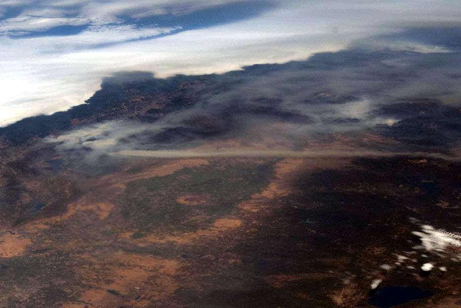
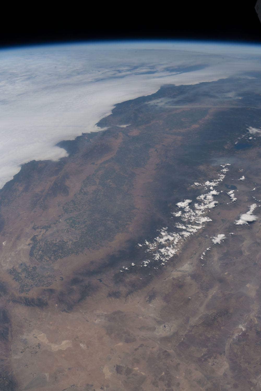
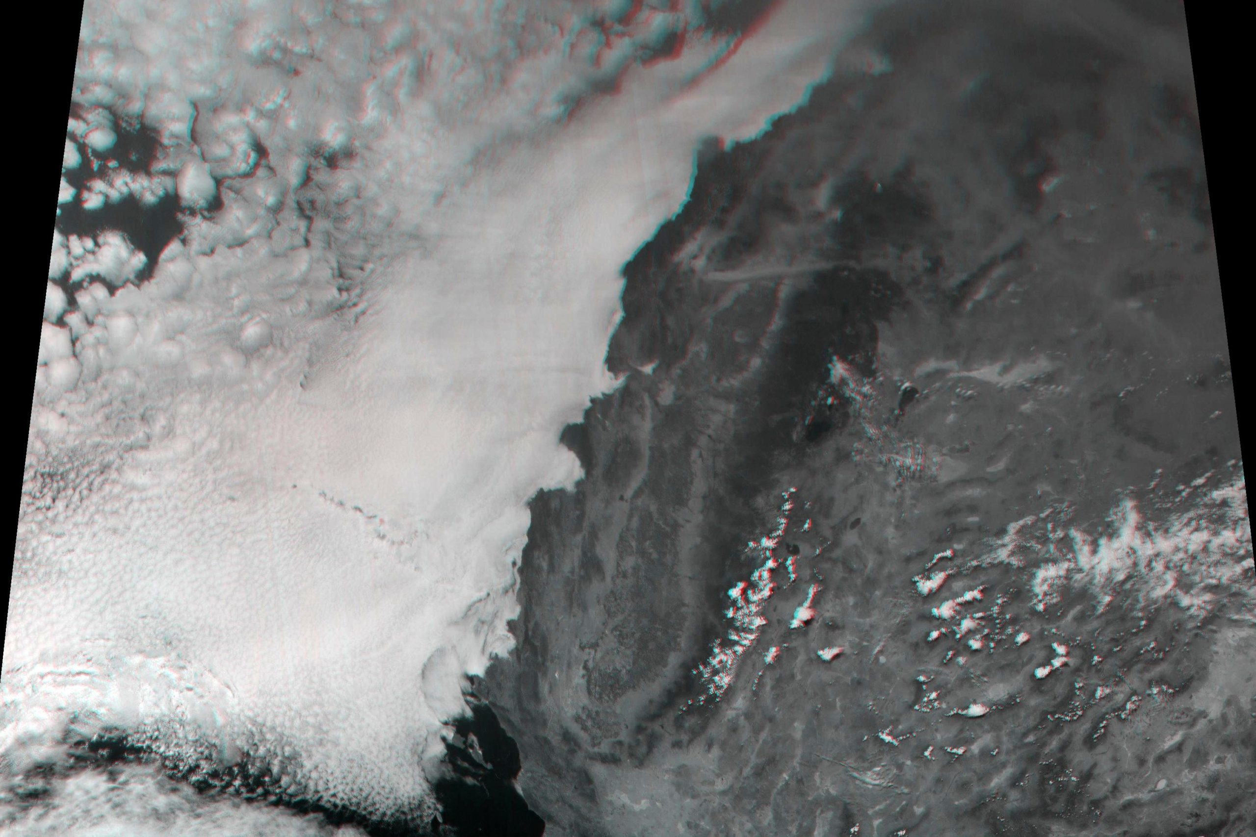
In support of the CyMISS wildfire observation objectives, the crew of the ISS Expedition 56 acquired a sequence of 240 images, like that shown above, stretching from the Pacific Ocean, across California and inland starting at 18:18:43 GMT on August 13, 2018 (see “ISS Daily Summary Report – 8/13/18“). These images were remapped and assembled into the color mosaic shown below providing a synoptic view of the region observed.
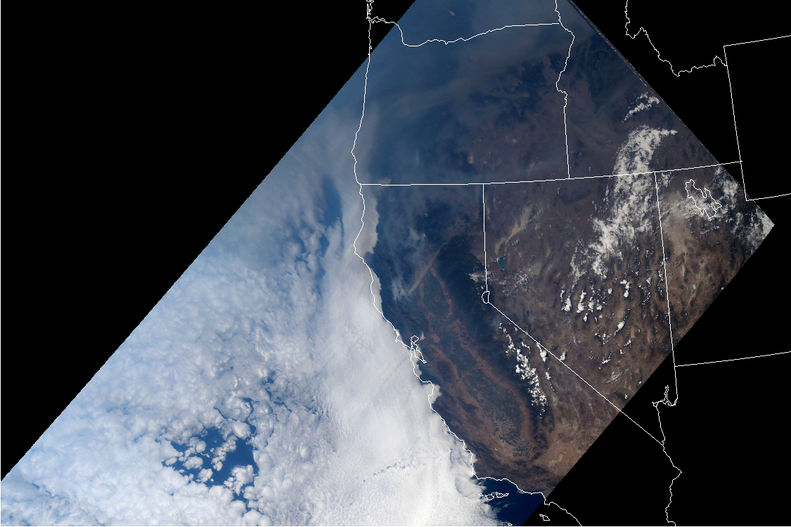
As can be seen in the color context image, the coast of California is obscured north of Lompoc by an extensive marine cloud layer. Only a short portion of the coast is visible south to the outskirts of Los Angeles. The upper right corner of the image farthest from the ISS shows multiple smoke plumes covering the area. To the south, isolated cloud formations frequently associated with the various mountain ranges are visible (see “Clouds over Mt. Whitney – A 23-Year Tale of 3D Remote Sensing“). A 3D view of the area, shown below, was created using the red channel of the color images to cut through the smoke and haze. With the large 20° stereo angle, the clouds in the Great Basin are especially prominent.
![]()
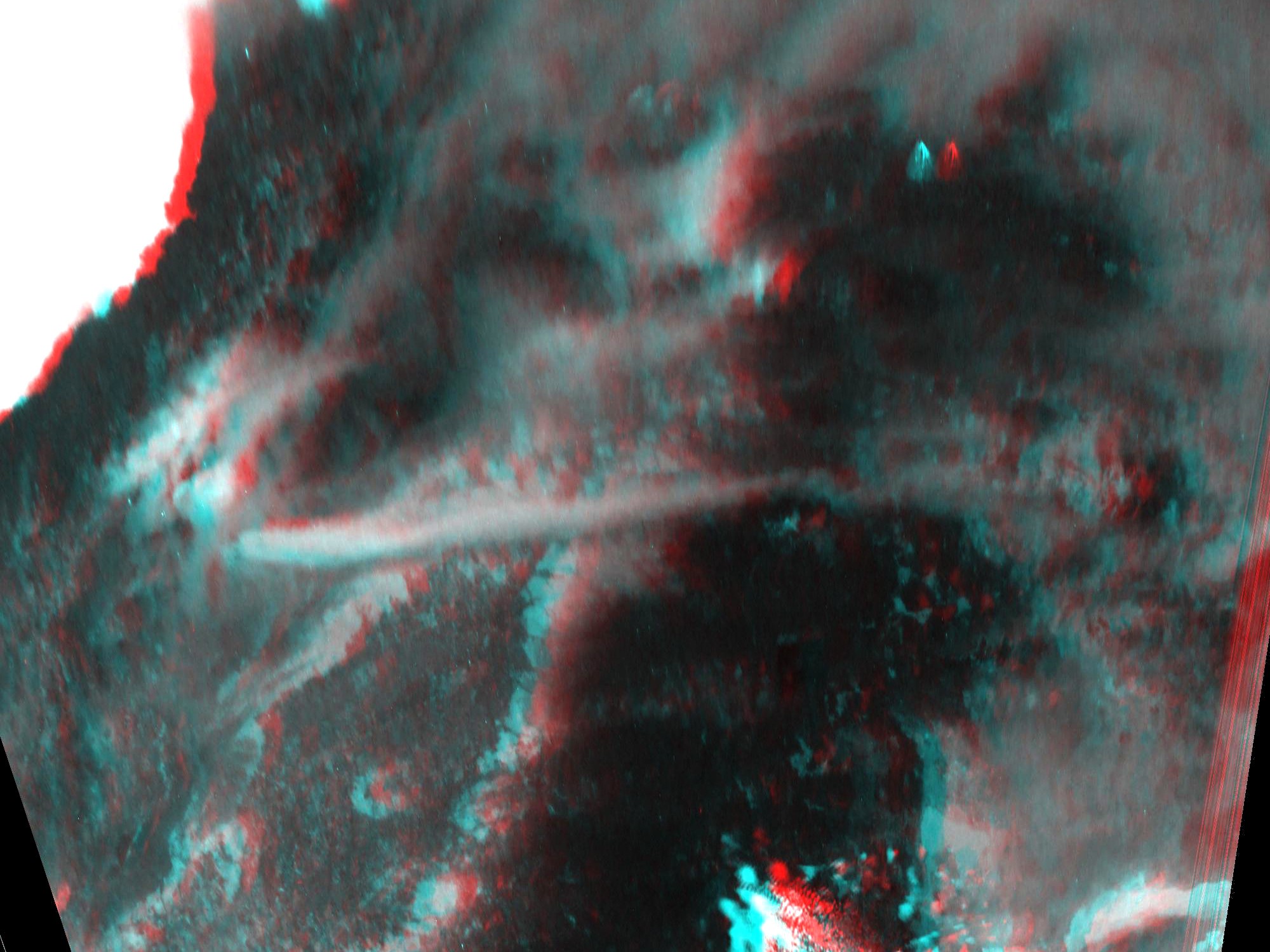
While smoke from the Mendocino Complex Fire covered a large region in the mountains near the upper center of the image, the most prominent smoke plume visible was associated with the nearby Carr Fire in the Shasta-Trinity National Forest on the west side of California’s Coastal Mountain Range. Started on July 26, 2018, the Carr Fire burned 229,651 acres (92,936 hectares) before it was fully contained on August 30. A long narrow plume of smoke can be seen stretching from the fire and across the Sacramento Valley until it reaches the Sierra Nevada Mountains to the east. The slant range from the ISS to this plume is about 1,080 kilometers yielding a pixel scale of 135 meters. The image below shows an anaglyphic 3D image created from a pair of 12-bit red channel images which have been processed to maximize the visibility of the plume. The plume can be clearly seen above the valley in this stereo view.
![]()
Potential for Observations from the Hurricane Hunter Satellites
The Hurricane Hunter Satellite constellation, currently being developed by Tropical Weather Analytics, offers the potential to spot wildfires especially in remote regions like the far north of Canada. Its 100-meter class stereographic imagery will be processed to produce geolocated 3D views that typically cover an area of 2000×2000 kilometers (see “The Hurricane Hunter Satellites”). As was demonstrated in the CyMISS stereo imaging exercise in 2018, this will allow analysts to quickly pick out smoke plumes and locate their source. In addition to 3D views, the imagery returned by the Hurricane Hunter Satellites can be analyzed to produce cloud (or smoke plume) altitude measurements for hundreds of thousands of points in a 2000×2000-kilometer observation to a typical accuracy of ±100 meters as well as 3D winds to an accuracy of ±1 meter per second in each component including unique measurements of the vertical wind component. Not only will this allow a wildfire smoke plume to be characterized, but it will also provide a large volume of data for wind forecasting models that can be used to predict the spread of the smoke. With typical revisit times of 2½ hours for the initial constellation of five 6U CubeSat pairs, the Hurricane Hunter Satellite constellation will be capable of monitoring the progress of remote wildfires during daylight hours.
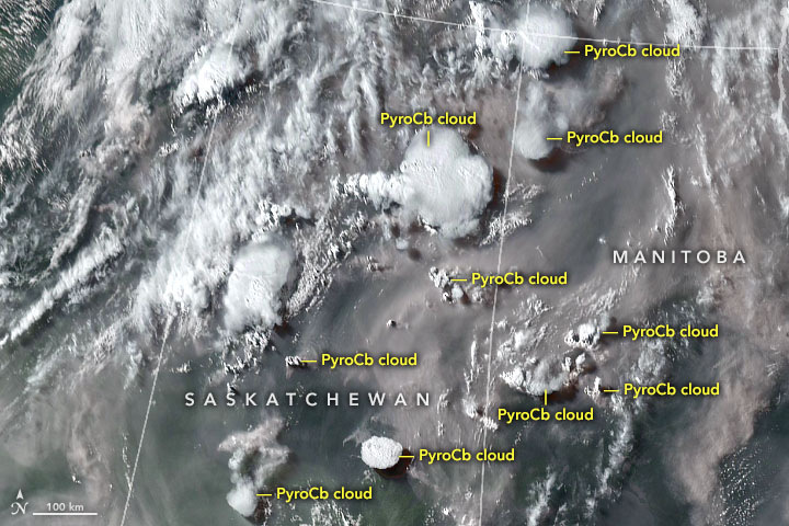
An increasingly common phenomenon associated with the growth in the size and intensity of wildfires is the formation of pyrocumulus and towering pyrocumulonimbus clouds. Created by updrafts generated by the intense heat of large wildfires, the formation of these clouds is accompanied by intense surface winds which can fuel the spread of a wildfire. In addition, pyrocumulonimbus clouds can lift smoke and other combustion products as high as the lower stratosphere. The stereo imaging capabilities of the Hurricane Hunter Satellites can provide data on the altitude and winds affecting the formation and spread of these clouds. The unique capability to measure the vertical winds associated with the updrafts of these events can be used to characterize the intensity of wildfires, help improve short term weather forecasts as well as gauge the potential longer term impact on climate.
Related Reading
Drew LePage, “The Hurricane Hunter Satellites”, Drew Ex Machina, May 15, 2022 [Post]
Paul Joss, “The Cyclone Intensity Measurements from the ISS (CyMISS)”, Space Station Research Explorer [Page]
Drew LePage, “Clouds over Mt. Whitney – A 23-Year Tale of 3D Remote Sensing”, Drew Ex Machina, November 28, 2018 [Post]